Can:Do at Colonnades, Noarlunga now has BindiMaps installed, making our indoor space 100% accessible!
After being diagnosed with a rare eye condition that would almost certainly result in total blindness, BindiMaps Founder and CEO Dr Anna Wright began pondering how she would manage everyday tasks once she lost her sight entirely. Spotting a Braille sign at her local shopping centre, Anna questioned how someone who is blind would even know the sign was there and so this sparked the idea of a smart phone app that would help people who are blind navigate large, complex and unfamiliar indoor spaces confidently, independently and safely.
Introducing BindiMaps, the wayfinding app.
BindiMaps adds a layer of convenience for most of us, but it completely changes the way people with vision impairment access indoor spaces as it removes significant barriers to navigation and opens a whole new world of discovery.
Since launching in 2017, BindiMaps has been installed in shopping centres, office buildings, hospitals, libraries, museums, and education campuses interstate.
By Can:Do installing the BindiMaps wayfinding system into our already state of the art facility at Noarlunga (located at Colonnades), we've further ensured that safe and accessible routing information is available to our clients. A particular benefit is the safety aspects for accessible and independent emergency evacuations if required!


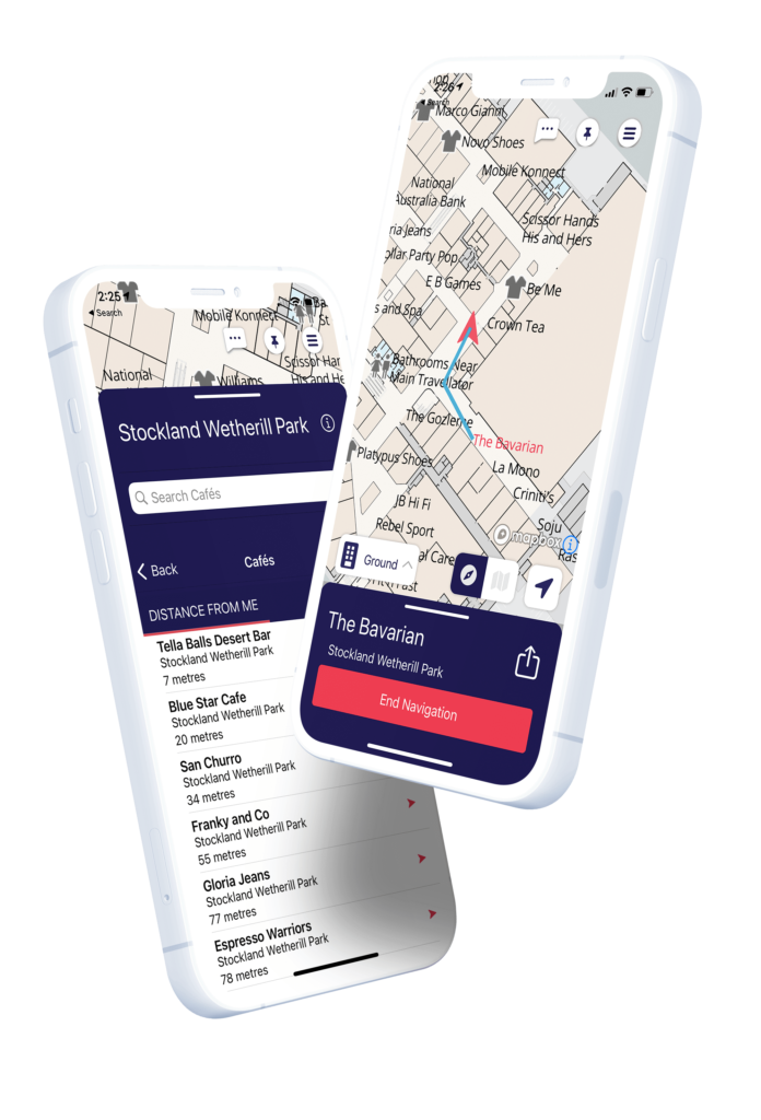
The Adelaide Central Market is also a known 'BindiMap' location. We ask all Councils to consider and encourage other local businesses to install, to ensure inclusiveness across Council areas.
WHERE GOOGLE MAPS ENDS,
BINDIMAPS BEGINS
Changing the way you navigate unfamiliar spaces.
What is BindiMaps? (more information for you)
BindiMaps is a wayfinding app. It makes it quicker to find your way around.
BindiMaps is completely free to use. Download the BindiMaps app and it will guide the way from the car park, train station or bus stop to the program or special event you want to attend.
BindiMaps is for everyone! You can choose to follow the map to reach your destination, or you can have the directions in text and audio.
BindiMaps is designed to assist users to precisely navigate to their desired location in indoor spaces. It uses a simple, natural language audio and direction mapping system to guide where you are, lets you know what’s around you, and tells you the best way to get to your chosen destination.
BindiMaps’ set of unique algorithms constantly updates the user’s position and calculates the most efficient route to their chosen destination. It uses a network of battery-powered Bluetooth beacons that are usually attached to the ceiling. It doesn’t collect personal identifying information, however when you open the mobile app for the first time, you are asked for permission to use location services. Some smartphones will also ask for permission to display your “precise location”. The app does require these permissions to be able to direct you effectively.


Start your child’s Can:Do journey
Call us
